The Dating Game

Let’s face it, I dated a lot before Colleen and I married. I was looking for that special something—my life-partner for a very important and specific part of my life. The funny thing is—now that we’re being totally honest—you’d think that 29 years of marriage would have slowed down my dating.

It didn’t.

If anything, it increased my rate of shopping around, even when I was married. Yes Colleen was a great spouse, etc., etc. While I won’t blame her for my continued searching, she was certainly an instigator—an “accomplice to the crime” if you will. She loved playing that role.

Well I am happy to say that after all these years, I think I’ve found my life-partner for this specific part of my life.

That life-partner is—drumroll please—the ukulele.

I’ve dated, and even had pretty serious relationships with, the guitar, bass guitar, keyboards, banjo and resophonic guitar. You see, I have a serious case of MIAS (musical instrument acquisition syndrome).

The reason I bring this subject up in relationship to this voyage is that two different musician friends of mine, Pete and Tim, have asked me if I have any music with me. I replied to both that although I’ve taken a minimalistic approach to cruising on HJ, there is no way I would contemplate a voyage of this magnitude without music—it’s unfathomable. There are so many other things that I would do without on my 31’ by 10’ castle. Nothing is better than being anchored-up in some secluded bay, or sailing through the night with HJ busting through waves like they’re marshmallows and I’m singing at the top of my lungs and strumming the uke to her.

Why in the world the ukulele you ask? I’ve thought about a lot that and think it comes down to 4 reasons: 1) portability—it’s small and can go anywhere, in addition I have a carbon fiber uke made by Klos Guitars that I love, it’s not affected by water and changes in humidity; 2) simplicity—the 6 strings of a guitar are just too much for me when playing up the neck; 3) it makes people happy—regardless of what you do with it, when people see it come out of it’s case, they smile; 4) expectations are lowered—after people smile, they think, “Oh, he’s playing a toy, I won’t expect much”. The aphorism “Happiness equals reality less expectations” ties together points three and four nicely.

In my dating of the ukulele, I’ve made a conscious effort to learn it and play it like a ukulele. Many guitarists play some ukulele because it’s trendy, think of the ukulele as the musical equivalent of kale. However, they play it as a small guitar. That’s fine for them but I didn’t want that.

Also, songs that sound truly good on the uke in my opinion have lots of chords. We’re talking diminished, augmented, minor 7th, minor 6th, etc. The chord structures really put the “Hawaiian sound” out in front of the music. Better musicians than I ascribe to the notion that good folk, rock, country and blues is three chords and the truth. Blues great Junior Kimbrough took it a step further. He said, “My songs, they have just the one chord, there’s none of that fancy stuff you hear now, with lots of chords in one song. If I find another chord I leave it for another song.” That’s great for those talented musicians who can make so much music and improvise on so simple of a framework. For me however, given my musical limitations, I enjoy more chordal variety to make up for what I lack in the improvisational area and the uke is perfect for that with its 4 strings.

As with people-dating, I’ve learned so much from my other relationships that I’ve brought to the uke. My West Virginia banjo teacher, Dwight Diller (his kinfolk pronounce it “DEE-white”) taught me that good mountain banjo playing is 90% in the rhythm of the right hand. If you mute the strings with your left hand, your right-hand rhythm has to be snappy enough that you want to get up and dance to just it, just the rhythm without the melody or chords. He also taught me that good banjo playing is like Japanese art. When a traditional Japanese painter paints a tree, they don’t paint the entire tree or all the leaves. They do it all with a couple deft brush strokes and let the viewer fill in the blank spaces. In the same way with music, there’s no need to play every note. The notes you don’t play are as important as the notes you play. Finally Dwight taught me that rather than “learning” hundreds of tunes…just stumbling through the chords and lyrics, focus on playing handful but play them over and over until you get truly good at them. I’ve taken these lessons, and lessons from other teachers of other instruments I’ve dated and applied it to the uke. I’m happy to say I’m having so much fun with it.

With DEE-white’s last lesson in mind, here are some of the songs I’m working on and their special meanings to me. I hope everyone finds music in their life:

All of Me – Try Willie Nelson’s version on his Stardust album.
Blue Skies – Same album from Willie. I was initially learning this song in the weeks after Colleen died and I choke up every time I think back to learning it on my back porch while my life was falling down all around me.
Take Me Home, Country Roads – Boy is this one making a comeback. Probably a close third on the karaoke circuit after Don’t Stop Belivin’ and Wagon Wheel. Toots and the Maytals have a great reggae version.
The Nearness of You – Nora Jones covers it at her finest.
You’ve Got a Friend in Me – Hard to imagine on the uke but is works (at least I think so). I think of Mike whenever I play this. Randy Newman is such a good songwriter.
I Can See Clearly Now – One word: inspirational. Written by Johnny Nash but I just love Jimmy Cliff’s funkier version.
Brandy – Hands down one of the best modern sailing ballads of all time.
The Girl from Ipanema – I dare you to listen and not dance.
Sixteen Tons – Old Crow Medicine Show does a great version.
Ain’t Misbehavin’ – Love, love, love Leon Redbone’s version with the violin.
Moonlight in Vermont – This one is fun to play in the moonlight, in the islands. I love Billie Holiday’s version.
To Live is to Fly – By the great Townes Van Zandt. His struggles with alcohol addiction are such a sad, sad story and a stark contrast to the beauty of his songwriting.

I’ll finish with Everybody’s Talkin’ by Harry Nilsson. The song contains the iconic lines that paint the picture of the Bahamas and Caribbean:
I’m goin’ where the sun keeps shining, through the pouring rain.
Goin’ where the weather suits my clothes.

I don’t know much about Harry Nilsson but I have to think that he had direct experience with mental health issues—most of us do. There’s still a lot of mystery around Colleen’s last 24-hours on earth and what she was feeling and sensing and doing, and what she was aware of. If I know anything, it’s that we will never have all the answers and have to live with the mystery. I tend to think she was in a really bad place with her prescription medications horribly out of balance. Some people in our neighborhood and community service agents reported that they did see her and tried to talk to her. Whenever I hear or sing these lines from Everybody’s Talkin’, I think of her and her last 24-hours on earth and try to imagine what she was going through:
Everybody’s talking at me
I don’t hear a word they’re sayin’, only the echoes of my mind.
People stop and stare,
I can’t see their faces, only the shadows of their eyes.

Pinch Me

I’ve been in the U.S. Virgin Islands National Park the past several days and have been so impressed with the hiking. The vistas of the mountains descending into the sea is incredible. Also, I love the flora, the cacti mixed in with other tropicals is such an interesting mix. It’s also amazing how empty it is. At-times you can hike for miles without seeing anyone.

In the National Park’s successful efforts to preserve the coral reefs, anchoring is generally prohibited within the park but the Park Service has permanent mooring balls (buoys) installed in select bays. It’s first come, first served and $26/night to moor—can’t beat it. I spent three nights in Great Lameshure Bay and a night at Salt Pond Bay. I hiked 5 miles my first day there and 8 miles my second day, and 4 miles my third. Below is the dinghy dock on Great Lameshure Bay where my hiking started. In the foreground, is my trusty inflatable kayak who is now named Sally (yes, I have a lot of time on my hands). Hazel James is the furthest right boat in the background.

Sally at the dinghy dock on Great Lameshure Bay

On days one and three of my hiking I did a lot of trails out to the end of headlands and points. They afforded great views of the nexus of land and sea.

Salt Pond Bay
Looking down into the water
HJ on her mooring in Salt Pond Bay (Bordeaux Mountain in the background)
Nice close-up of both HJ and the mooring ball
Looking down from Ram’s Head Point
Absolutely beautiful colors
I startled this soldier crab on the trail
Ram’s Head Point with the British Virgin Islands in the background
Amazing cacti (and sailboat in the distance)

On day two of hiking, my longest day, I hiked into the interior of the island of St. John. In addition to panoramic views, I saw a number of sugar cane processing ruins and petroglyphs.

View from Bordeaux Mountain (elevation 1,277 feet), Hazel James is down there in that bay (if you look carefully at the horizon, you can see St. Croix)
Other vistas
The first ruins I visited was the Reef Bay Great House, it was the main plantation house of the Reef Bay Sugar Factory
Beautiful flowers and bees surrounded The Great House
On my hike to the Reef Bay Sugar Factory ruins, I ran across this orchid
The above orchid’s root structure (when you are an epiphyte, it’s all you need)

The Reef Bay Sugar Factory ruins were fascinating. It’s where sugarcane was crushed and the juice boiled to produce sugar. The factory had two lives. In the first, horses were used to crush the sugar cane by being harnessed to a long sweep and walking in circles. At the center of the sweep was a crushing mill. In the factory’s second life, steam power was used to do the crushing.

It was especially apropos timing for my visit as I’m deep into the book Waking Up White: And Finding Myself in the Story of Race by Debby Irving. Thanks to my friend Jessica for turning me on to it. It was powerful for me to see these ruins from the early 19th century and think about the institution and infrastructure of slavery required for the operation. In touring the site I kept thinking about while these ruins are fading away, the pernicious, self-perpetuating inequities between races continues. I haven’t made it to the so-what-can-I-do-about-it part of the book but am anxious to get there and reflect on my life’s future course.

I recommend the book highly. One interesting thing that I learned relates to the etymology of the word “Slave”. It likely originated as “Slav”, the term used for captured white Slavonic people sold by other Europeans to Arab’s as indentured servants during the eights and ninth centuries. In the Americas, the earliest slaves came in a variety of skin colors and from a variety of countries, including homeless children from London. Some racial justice educators and descendants of of those enslaved, advocate for the term “enslaved African” instead of “slave” to convey that it was an act done to the person against their will, and not an inherent identity.

The Reef Bay Sugar Factory
The steam engine used in its second incarnation (note the shaft going through the wall, you’ll see the other side in a subsequent picture)
Really cool close-up of the governor on the steam engine

My dad and I are big fans of steam engines. It was wonderful to see the governor in such good shape. As its name suggests, the governor, governs the speed of the steam engine. The two iron balls are spun by the steam engine and they counter-balance each other. The faster the engine goes, the more centrifugal force drives the balls outward and lifts them. There is a steam regulating valve in the center shaft and as the balls lift, the valve begins to shut, reducing the steam fed to the piston. Conversely, when the engine slows, the balls drop opening the valve. Thus the governor regulates the engine from going too fast or slow.

Here’s the view from the outside, the small pinion gear in the lower left is coming from the steam engine. It drives the large gear which then drives the sugarcane crushing mill.
After the Reef Bay Sugar Factory, I had lunch on this deserted beach and took a nice swim
Wow, they grow the spiders big here

My next stop was at a spring-fed and waterfall-fed freshwater pool on St. John (fresh water is a rarity). Because of the springs it stays at nearly the same level regardless of the rainfall.

Another hiker took this one of me in front of the mostly-dry waterfall

The petroglyphs here were fantastic. They were carved by the Taino people 900-1600 AD. The style of art matches designs found on Taino ceremonial pottery. Archaeologists believe both the pool and the carvings were sacred to them. They further believe that the placement of the petroglyphs, just above the waterline of the pool was intentional. The reflections embracing the duality of the spiritual world and the living world. It was moving to be in another peoples’ sacred space.

Petroglyphs and reflections
Close-up
I guess they had some angry Gods too
I thought this petroglyph looked confused more than anything (I guess if I were carved more than a thousand years ago and today hundreds of people point clicking devices at me, I’d be confused as well)

My last hike was to Drunk Bay. Not sure where that name came from but it’s the closest I’ve been to drunk in a few years. It was on the windward side of St. John so the waves generated by the trade winds broke on the rocky beach. It was beautiful to just sit for awhile and watch it all happen.

My last hike was to Drunk Bay

All-in-all the National Park is so impressive. It’s a fun hybrid of “U.S. National Park” with feeling like a different country. Although regulated and controlled to help ensure preservation, the petroglyphs and ruins exposed to the elements, spotty signage, and lack of crowds remind you that you are nowhere near the mainland U.S.

And, oh by the way, the sailing and snorkeling are fantastic as well.

A Birthday Tribute

Today is my father Dave’s 92nd birthday. Although I’m moored in a secluded bay of the Virgin Islands National Park on St. John USVI—a literal paradise, I so wish I could be transported to Pittsburgh for his birthday party.

Being away from home the past 43 days and sleeping every night on Hazel James has given me time to reflect on everything he has done for me and how the person that he is has helped make me the person I am. It’s also given me the time to think about the relationship that he and Colleen had. He dearly loved Colleen and she him.

Professionally my father was an engineer, a metallurgical engineer, educated at Carnegie-Tech (before it became Carnegie Mellon). More than being educated as an engineer, he had the mind of an engineer. He could, and did, fix most anything around the house, and was constantly tinkering with things and inventing things. As a for-instance, long, long before TV remotes (remember 13 channels plus UHF and VHF?), he became convinced that advertisers increased the volume just slightly during commercials—I think he was right. This incensed him. So, to my mom’s chagrin, he took apart our first color TV and found the wires to the TV’s speaker. He inserted a pull-chain switch in the positive wire to the speaker and mounted the pull-chain switch on the outside of the TV, upside down. He then ran a string from the pull-chain up to the ceiling and through a couple small pulleys and down to the head of the kitchen table. Whenever a commercial came on, we just pulled the string and muted the TV. Brilliant, just brilliant.

I so vividly remember Saturdays and Sundays working in our basement tool room on projects with him. On my passage from the Bahamas to the Virgin Islands I was fixing and jury rigging a rather complex fitting that had broken and was essential to our continued sailing. While working through the problem, I thought of all he taught me from a mechanical perspective.

Ending the story right there would be more than enough. However, it’s not even half of it. He instilled the love of sailing in me. Although Hazel James is 31’ and displaces (weighs) approximately 12,000 pounds, the basics of sailing still apply and what he taught me about sailing small boats on inland lakes I use to this day. Growing up, combining sailing, engineering and not having a lot of disposable income—he and I built and re-built countless boats in our garage in the winter. On the weekends while working on our latest nautical project, we’d listen to classical music on the radio or tapes of poets reading their poetry (Robert Frost was dad’s favorite). A couple years ago, thanks to my sister and brother and brother-in-law and sister-in-law, we got him out sailing on Hazel James—the thrill of a lifetime.

Dad at the helm of Hazel James

The previous comment about music and poetry brings me to my next point about my dad. It’s one thing to be a great engineer. It’s another to be a great lover of the arts and amateur artist. However, how often to you see the combination of those two in a person? My dad was so rich and taught me so much about the power of combining science, technology and math with the beauty of art and the beauty of life. He introduced me to classical composers, and great authors and poets. When I went away to college and was questioned by school guidance counselors about my intended field of study, I replied “Engineering” as if there was no choice. However, through it all seeing the art in life and appreciating the beauty in life is more precious to me than all the formulas and equations in the world. He gave me that gift and opened my eyes to it.

I was born in 1964 so the picture below is probably from 1965, maybe 1966. My dad is playing the baritone ukulele and whistling—he whistles to this day. You can see what he’s giving me and how I’m soaking it up as only a child’s brain can soak-up experiences.

Dad with my sister Amy and me, 1965 or 1966

That’s my sister Amy in the photo as well. She died in 2013 at the age of 54 of cancer, one year after my mom, Ruth, died.

As a final note, it’s inspiring to me and to so many others just how positive my dad is to this day. To think that he has lost his wife of 60+ years, his daughter and his daughter-in-law and remains so upbeat is a testament to his outlook on life.

Happy birthday dad. I love you.

Ship Ahoy! (from the passage)

On the afternoon of Valentine’s Day, 2 days out of Harbour Island Eleuthera, Bahamas, I had a good close encounter with a freighter. I say “good” for a couple reasons. From a Murphy’s Law perspective, so often when you have a close encounter with a freighter or cruise ship, it’s 3 AM, the wind is howling, there’s another freighter coming from the other direction at the same time, and on and on. In this instance, HJ was sailing herself at 5 knots in a favorable direction so I took some time to think through what I really should be doing in a close encounter.

Below decks, to the left of HJ’s navigation station (a.k.a., her nav station) is the electronics panel. I currently have her outfitted with 6 different electronics: primary GPS, back-up GPS, VHF radio (very high frequency) for short-distance communications (say closer than 30 miles), AIS, radar, and satellite weather/email/text. When in typical sailing mode I run the primary GPS, VHF radio and AIS. Radar is a power hog for a low-power boat like HJ so I only use it when in close quarters.

The AIS (Automatic Information System) unit is a relatively recent invention and an incredibly useful tool. Basically it’s a transponder—that is, it both transmits and receives—over VHF frequencies. When powered-up, my AIS unit is transmitting both static and dynamic information about Hazel James. Static information includes ship’s name, length and beam (width). Dynamic information includes our position, speed and course over ground (COG). Other ships’ AIS units are doing the same thing. Large ships and most all passenger vessels are required to run an AIS. Small vessels (such as HJ) are not, but it’s a darned good idea. Given my AIS unit ”knows” my dynamic information (position, course and speed), when it picks up another vessel’s signal it can determine the CPA and TCPA for our two vessels (Closest Point of Approach and Time of Closest Point of Approach)—as you can imagine, very important information to have. It’s hard to explain just how deceiving and confusing moving ships can be. Also, the AIS can “see” out to a distance of 24 miles. I can only physically see 3-8 miles depending on day/night, atmospheric conditions, etc.

With all that being said, in my every-thirty-minute checks of the horizon and AIS, I picked up a ship on the screen.

Hazel James’ Automatic Information System (AIS) unit

In the image above, we (HJ and I) are the black boat/triangle in the center of the screen. “N-UP” at the top of the screen indicates that we are running the unit with north being up (similar to the option on a car or phone GPS). You can tell our course over ground (COG) is roughly due east since that’s the way our boat is pointed on the screen. In this picture, the target ship currently has a range (distance) of about 4 nautical miles from us. One way to tell this is by the “12nm” in the bottom-left. That indicates that the max range of this setting of the AIS is 12 nautical miles. Therefore the concentric circles are each 4 nautical miles. Most importantly the CPA (closest point of approach) is currently 1.3 nautical miles—a comfortable distance, and the TCPA (time of CPA) is 17 minutes. Now keep in mind that I had “seen” the ship on AIS and visually much earlier. Also, not shown on this screen but visible elsewhere is the ship’s speed. In this case 16 knots, much faster than Hazel James’ 5 knots.

In climbing on deck for a visual, this is what I saw off my starboard (right) bow…

The Seaspan Amazon, hailing from Hong Kong

I could have left it at that and just enjoyed watching her pass safely off my bow. However, since I had some time on my hands, I decided to work on my radar skills. I’m good enough to get by with radar but always take the chance to practice in a controlled setting. Radar is a much older technology, it was invented in the 1930s.

About halfway up HJ’s mast is my radar transmitter and receiver, technically called the radome. In the image below (a cool camera shot if you don’t mind me saying so), the lower and wider unit with the blue base and the white top is the radome. In a related note, the narrower taller unit is a radar reflector to increase HJ’s radar image to other ships (technically called an RTE, radar target enhancer).

HJ’s radome and RTE on her mast

When transmitting, the radar is sending radio signals and receiving any echoes from those signals. There’s a lot more art involved with tuning and interpreting radar data as compared to AIS data. With the AIS you pretty much turn on and it runs. Radar takes a bit of work. However, if you see a ship/boat in the distance and don’t pick them up on AIS, they may not have AIS on board or may have it switched off. This happens a lot, as the high-seas are full of weirdness. Captains who don’t want to be seen for various reasons and military vessels don’t transmit AIS information. Conversely, radar doesn’t depend on the other boat to transmit anything.

There is an absolutely amazing story about the early days of radar in WWII. In 1939, the US military established the AWS (Aircraft Warning System) using “RADAR” (RAdio Detection and Ranging). On December 7th, 194 1 at 7 AM, radar operators from the Opana radar installation in Hawaii detected approaching aircraft at a range of 150 miles. After much back-and-forth between the operators and their command, they concluded it must be an incoming flight of B-17s—a tragic, tragic mistake. More on this here if you’d like to read.

Back to my story… I flipped on my radar and easily picked up the Seaspan Amazon on our radar screen. In the image below, the solid line is HJ’s direction of travel, again, we are in the middle of the scope. The blip to the right of the screen at a range of 4 nautical miles is the freighter. Interestingly, I put an EBL (electronic bearing line) on the screen to double check that the Seaspan Amazon would pass well in front of me. A “bearing” is another ship or target’s direction from your current position. The EBL is the dotted line below. I placed that line directly on top of the target ship’s blip several minutes earlier. You can see below that the ship has advanced in-front of the EBL indicating that it will pass in front of me (off my bow). Conversely, if the target had fallen behind my EBL, she’d pass off my stern (behind me). Finally—and you guessed it—if the target stays on the EBL, you’ve got trouble that you need to deal with…and quickly.

HJ’s radar screen with the target clearly visible

Back to the art of radar, the Seaspan Amazon is huge and it was an extremely calm day on the ocean. Radar gets a lot tougher when you’re trying to pick-up smaller vessels in rough seas and in rain, when the waves and precipitation are creating noise on the radar screen.

After all that, the Seaspan Amazon passed us a mile off our bow.

The Seaspan Amazon off our port (left) bow

I said the Seaspan Amazon was huge? We’re talking 337 meters in length. That’s 1,100 feet or two-tenths of a mile long; 35 Hazel Jameses lined-up end-to-end would still be shorter than her. She can carry 115,000 tons of cargo. That is, she could carry 15,000 Hazel Jameses. The size is just mind boggling.

Although I don’t think there is any connection between Amazon.com and the Seaspan Amazon, the next time you order something online, take a moment to think about the size and shape of the global supply chain that is so much a part of everyday life and how stuff gets from here-to-there.

Thanks as always for reading and Hazel James out.

Overall Thoughts on the Passage

Now that I am in the Virgin Islands, I can be a little bit more “transparent”. When I say transparent, it’s a euphemism for “honest”—because, let’s be honest, I haven’t been totally honest.

Over the past several months, when I would tell well-meaning friends about my idea to sail 1,000 miles of open ocean over 10-15 days by myself, generally the first question was, “Have you ever done anything like that before?” I would answer with a halfway confident, “Kinda”. But, when I said “Kinda”, I really meant, “Not even close and I don’t even know what I’m getting myself into.” However, looking at that last sentence I just wrote, that’s not fair either. I had done a lot of reading and a lot of preparation. I would say that I knew intellectually what to expect but I really didn’t know what to expect from the emotional and stamina perspectives. I have quite a number of notebook notes and audio notes that I made during the passage and, over time, I will put them together into blog posts. What I’d like to do here though is provide an overall perspective and some salient remembrances.

If I were forced to boil the whole thing down into one lesson—into one thing that I learned—it would be this: Don’t, Freak, Out. When I say those three words aloud to myself they are so impactful and meaningful to me. However, when I type them and see them in front of me, they just look like three words. When I say them though, I say them slowly and in a metered rhythm. I also accentuate the first couple letters of each word: DOH—FRE—OWW. The second half of each word comes along for the ride. Try saying them to yourself, aloud. Maybe the spirit and meaning will come through.

I boil it all down to “Don’t freak out”, just because it would have been so easy to do so. Things that go awry when you are a couple miles from shore are totally different than the things that go awry when you are hundreds of miles offshore and by yourself. If you were to fall off your boat a couple miles offshore, your pride would be bruised no doubt, but it would heal. There’s no button to press if you want to stop the ride and get off.

Related to the don’t-freak-out concept and I think also proving the point, is a follow-up lesson for me: The ocean is big. Again, a simple concept and one that I knew intellectually. However, in the middle of the passage, I went for 2 1/2 or 3 days without seeing another ship. This includes not seeing anything on my every 30 minute checks of my AIS unit (Automatic Information System). It essentially extends my field of vision to a 24-nautical mile radius. In the daytime, I could see a ship maybe 5 miles distant. At night, add a couple miles if you count just seeing the glow of its lights. I was talking to my daughter Emma about this the other night and she wondered…how many people alive today have had the opportunity to be over a hundred miles from any other human being? It’s an interesting question that I hadn’t considered.

What’s crazy about this as well is that I wasn’t in the “middle” of the ocean. Sure, I was well offshore, but not like I was in the middle of the Pacific or something. Interestingly also is that I saw very few jets in the sky. I guess it’s because jets, like ships, don’t just fly around. They stick to their lanes. In looking back through my notes, when I did see one jet I wondered what the 200 or 250 souls onboard were thinking. Were any looking out the window down at the sea? Were they thinking about its size, power and expanse, and what we as a human race are doing to it? If so, it was probably the children onboard who were asking themselves those questions. Picasso said, “Every child is an artist. The problem is how to remain an artist once we grow up.”

I was 3 or 4 days into the passage when I was visited by the most beautiful seabird I’d ever seen. I’m sure it’s beauty in the eye of the beholder (me) was enhanced by my sensory deprivation. It was a White-Tailed Tropicbird (thanks for the ID help MVK).

White-Tailed Tropicbird intrigued by HJ

It flew around HJ for 10 or 15 minutes and actually made several unsuccessful attempts to land in her rigging.

Trying to land in Hazel James’ rigging

I can understand a soaring seabird such as a Magnificent Frigatebird staying aloft well-enough to cover hundreds of miles, but the tropicbird is a “flapper”, it flies much more like a tern or a gull. To think of it, hundreds of miles from land was mind-boggling to me. Several hours later, I was visited by a pair of them. I spent a lot of time thinking and wondering about many questions. Was one of them the one I saw earlier? Are they a life pair? If one of the pair was the single bird I saw earlier, how did it communicate to it’s mate about the discovery of Hazel James?

The dichotomy of, on one hand, being in a boundless place—and on the other, being bounded by a 31 foot by 10 foot fiberglass hull was disorienting. What was orienting though were the stars, the planets and the moon. I could see the hourly and nightly changes in the sky like I never had before. Also, as I sailed south, I saw new stars in the southern sky every night. This climaxed two nights before I made landfall in the Virgin Islands when I saw the Southern Cross rise low in the southeast.

When you see the Southern Cross for the first time
You understand now why you came this way
‘Cause the truth you might be runnin’ from is so small
But it’s as big as the promise, the promise of a coming day

—Crosby, Stills & Nash

Most every night I also saw bioluminescent plankton in my bow and stern wakes. Many times on cloudless and moonless nights, I’d turn off HJ’s running lights and turn off all unnecessary electronics. I left my AIS and GPS running but dimmed their displays to black. The combination of the stars and planets above with the bioluminescence below was worth every bit of effort it took to get there.

Here are a couple shots of me on the passage…

Daytime in the cockpit jotting some notes about things I’d like to later write (Colleen knit the hat I’m wearing for herself. It’s nice to wear on chilly days as good luck.)

Sometime in the middle of the night between naps on a bean bag chair with a sleeping bag over my legs (yes, I did have Chartis swag on-board)
On the foredeck in the middle of a sail change

After three nights in a marina with hot showers, laundry and restaurant food for me, and some minor and not-so-minor repairs, a good washing with biodegradable boat soap and a lot of reorganizing for HJ—we are back in fighting-trim and ready to go. Tonight we are anchored-up in Christmas Cove, on the lee side of Great St. James island (just off the coast of St. Thomas island, USVI). Tomorrow we will sail over to St. John (still USVI) and do some snorkeling and hiking in the national park.

I can’t express how much you all mean to me. So often, during a beautiful part of the passage (like the sunset below), I’d think, “If only my family and friends were here to see this with me….” Perhaps that’s the way climbers feel when the summit a great mountain.

Twenty years from now you will be more disappointed by the things you didn’t do than by the ones you did do. So throw off the bowlines. Sail away from the safe harbor. Catch the trade winds in your sails. Explore. Dream. Discover.
—This is one of my favorite “Mark Twain” quotes. However, in researching it turns out that it may have been H. Jackson Brown, Jr. or someone else who first said it. Regardless, it’s great.

Land Ho! (part II)

Thanks to Jack for keeping the site updated while I was away and also posting about my landfall.

Midday Sunday, February 23rd, after 11 days of sailing, I saw land for the first time. It’s funny, over the past day or so, thinking about approach-options to the Virgin Islands and where I make landfall and check-in with customs and immigration, I never really thought about that first sight of land. Also, where HJ and I hail from, South Florida, the land is low—beyond low—and “seeing land” when making landfall means seeing the tops of condominiums over the curvature of the earth. Interesting but not impressive.

Conversely, the first sight of land in the Caribbean is impressive. St. Thomas of the USVI rises 1,700 feet out of the ocean. As I would later find, you can be sailing a quarter-mile off the land and be in 160 feet of water. Also, I knew it was coming because over the past two nights at sea, I’ve been seeing the horizon-glow of the city lights from San Juan, Puerto Rico and Charlotte Amalie, USVI. 

Shortly after noon local time on Sunday (I’ve travelled so far east that I am in the Atlantic Time Zone), I was sitting in HJ’s cockpit while she sailed herself in a south-southwesterly direction. I was taking midday sights with my sextant to determine our geographical position using the sun’s passage over our local meridian (the line connecting the north pole and south pole, and our position). One could argue this is totally unnecessary given that the GPS does this for me many times per minute. However, in my quest to earn my distance, I’ve been teaching myself celestial navigation—more on that coming in a different post. 

Me taking a sun-sight at anchor in a very-calm setting (there’s no way I would try to take a selfie of myself while taking a sextant sight on the open ocean when we’re pitching and rocking)

As you see in the image above, the sextant has a small telescope on it. I’d say it’s about 6 or 8 power, about the same as a weak set of binoculars. When you look through the sextant’s telescope, you see both horizon and the sun superimposed; the way the sextant works, the sun actually appears in front of the horizon. To take the sight, you adjust the sextant until the sun’s image appears to sit on the horizon. Then you note the height of the sun from the sextant’s arc and the exact GMT (Greenwich Mean Time) and do lots of manual calculations. Again, more on this in another post. As I was taking the sight, I saw what looked like a mountain on the horizon. I thought, “What the heck… am I seeing things again?” (wouldn’t be the first time after 11 days) Then I blinked and it was still there. It then hit me that I should be seeing land soon as we were 23 nautical miles out at that point. Crazy because if South Florida weren’t built up, you’d probably be 5-7 miles out before you saw land, it’s that low.

First view of land of the bow (front of boat), 23 nautical miles out
Incidentally, one of my last views of land off the stern (back of boat) 11 days earlier, Harbour Island, Eleuthera, Bahamas

To celebrate, I made myself a glass of limeade and toasted (reamed one lime into a glass, added two teaspoons of sugar and water). Quick aside, British sailors are nicknamed “Limeys” because when it was discovered that lime juice both cured and prevented scurvy (because of the vitamin C), the queen’s sailors were rationed one lime per day when on passage.

The rest of the day, we were sailing hard on the wind (sailing into the wind). Not a sailboat’s fastest point of sail—especially a blue-water cruiser like Hazel. Therefore, it was another 4 hours of sailing before we were really close to the islands. It was fun and exciting to see the sea life and birds change and appear as we approached land. I saw a mixed group of Frigate Birds and Brown Boobies going after a school of baitfish that were being pushed to the surface by larger fish below.

I learned from studying my charts that not far north of the coast of Puerto Rico and the Virgin Islands lies the Puerto Rico Trench. This oceanic trench is the deepest in the Atlantic and helps define the boundary between the Atlantic Ocean and Caribbean Sea. It’s dizzying to think that you’re sailing over water that is 27,500 feet deep. I know you can just as easily drown in your bathtub but still…. Later, I did some quick internet searches and estimate that if I had dropped a penny in the water over the trench, it would have taken 2 hours and 40 minutes for it to reach the bottom.

As I said, it took me another 4 or so hours of sailing to be in close proximity of the Virgin Islands. Unfortunately this put us at sunset. There’s no way you should be trying to navigate an approach to land in the dark in a area you’ve never sailed before, so I had no choice but to heave-to for the night. Heaving-to consists of putting the boat‘s sails and rudder in a configuration where they purposefully work against each other. Similar to a plane, the boat stalls and moves very little (I averaged ~1 knot for the night [1.2 MPH]). Unlike a plane though, the boat is bouyed by relatively dense saltwater; a plane’s buoyancy comes from the air around it and it will drop like a proverbial stone when it stalls. Still, as in the open-ocean, I had to maintain my schedule of 30 minute cat-naps to check my position, make sure there were no major wind-shifts while I was asleep and make adjustments. 1 knot is dead-slow far from being safely on anchor, especially when you are only a couple miles from land.

Needless to say, I greeted the light in the east around 5:30 AM and the sunrise around 6:30 AM with gratitude.

My first sunrise off the Virgin Islands, the U.s. Virgin islands are to the right, the British Virgin Islands are to the left

The next morning I sailed and motored to Cruz Bay, USVI on the western side of the island of St. John and cleared customs and immigration. I then had a good lunch ashore and also visited the US National Park office while HJ sat at temporary anchor (it’s a busy port-of-entry so I was in a max 3 hour anchoring zone). About 2/3rds of the island of St. John is national park and Hazel and I are excited to explore it after we get cleaned up, organized and lick a few of our wounds. Later that day, as my 3 hours expired, I found a marina with availability on the eastern side of the island of St. Thomas (also USVI). HJ and I motored the several miles to it and tied-up.

All-in-all, we covered 1,160 nautical miles during the 11-day passage (1,300 statue or “land based” miles). Here’s our overall track…

Track. via GPS
Track via paper chart

In the GPS track, you can clearly see the variations from our intended course (the waypoint red “X”s) and our actual course. The wind and currents will do what they will do, oblivious to me, my situation and my desires. Just as clearly as the GPS-track, there is a life lesson there for me and I hope for you.

I have lots of remembrances, written and audio notes, and photos of the passage. If you’ll indulge me to keep following this site, I’ll be posting them as I have time to put them together.

My son Jack graduated with a Master’s Degree in Environmental Policy and Management this past December. It was a powerful and wonderful experience for him. As he finished his last papers and finals, I asked him if he was excited about finishing. I thought his response was so interesting: he said he had mixed-feelings about finishing the program. Although he was excited to get the degree, he would also miss the program, professors, fellow-students and intellectual stimulation. I feel that way about finishing this passage—mixed-feelings but all of them good.

I’m writing this from HJ’s rather messy saloon, a lot happens on passage and on making landfall that you put-off and don’t worry about until later.

A “few things” to clean-up and get organized

Last night I slept like the dead for 10-straight hours. For 12 nights I had been working on a roughly 30-minute catnap cycle. When I finally came-to this morning, I blinked and thought, “Did that all really happen? Was it just a dream?” I poked my head out of Hazel James’ companionway and found that I really was here.

View of the marina the next morning

Thanks as always for reading and I so-appreciate your comments back.

Land Ho!

02/23/2020: PompanoDan Voyage update:

Dan has nearly made it to The Virgins. As of this morning he expects to Anchor near St. Thomas tonight, and then find a marina and check-in with customs tomorrow, Monday. Below are a few images from the MarineTraffic app of Dan’s location as of roughly 9:41 EST this morning.


I imagine Dan will be updating the page in the next day or two as gets access to wifi.

Jack

Briland / Harbour Island / Dunmore Town

“…shiver me timbers
I’m a-sailin’ away”
—Tom Waits, Shiver Me Timbers

While confusing, all three of the names entitling this post refer to the same place. At one time Dunmore Town was the capitol of the Bahamas and was also a prosperous shipbuilding town. Harbour Island, the island on which Dunmore Town is located, is roughly 3 1/2 miles long and 1 1/2 miles wide. The town occupies most of the island. Finally, “Briland” is the local and affectionate name for the area. It’s a contraction of Harbour Island; imagine “Harbour Island” becoming something like Bour’island then “Briland”. The locals have a wonderful half-British, half-islander accent—to hear them say “Briland” is musical.

For the past 6 nights, I’ve been anchored up about a quarter mile off the shore on the west side of Briland. Over the island and to the east, lies the Atlantic Ocean that I hope to be sailing this afternoon. Last night, I stayed in a marina comfortably tied to their docks. While I sleep on Hazel James at a marina, I enjoy hot showers, laundry, dock space to organize and fresh water to wash down. While at anchor, most days I’ve been paddling my inflatable kayak into town, beaching it and locking it to a tree, and exploring the island. There’s probably no need to lock it given the culture here, but since it’s my one-way on and off of HJ, I don’t want anyone messing with it.

HJ lying to anchor off the coast of Briland
Kayak on the beach ready to return to HJ with backpack and provisions

At anchor at night, a boat is to display an all-around (360 degree) white light referred to as an “anchor light”. This warns other mariners to keep clear. I’ve gotten smart on my anchor light and if there is any chance I won’t be back to HJ until after dark, I’ll flip on her anchor light before I depart in the kayak even if it’s in the middle of the day. It’s nice to not rush a dinner just to get back for the anchor light. It also makes HJ easier to find in the dark.

View from kayak about 7:30 PM a couple nights ago. I’m paddling toward HJ and she’s a couple hundred yards away. Her anchor light is the highest light in the picture. Notice how her hull blocks out the background light and reflections on the water.

I’ve never seen Bermuda’s pink sand beaches, but those who have seen both Bermuda’s and Briland’s say that Briland’s are pinker. I took this picture on an overcast day that doesn’t really do it justice.

Pink sand beach
Walking down to the beach (note coral heads right off the beach in the Atlantic)

It’s a pretty little town. Lots and lots of chickens and golf carts. Even when anchored up, when I wake before sunrise I hear a brilliant cacophony of roosters crowing.

Golf carts and resort
A house with a lot of pride and care put into it
The post office
“Briland Thyme” restaurant
Methodist church
Graveyard behind Methodist church (the owner of the chipped headstone in the middle of the picture died in the 1890s)
Low tide

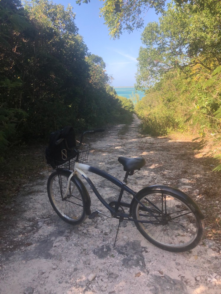
I think what impresses me the most is that the people are so nice. It’s hard to walk anywhere in this town without someone in a golf cart slowing down and motioning for me to hop on—which of course I do. Not once in my 5 or so excursions, with lots of walking through all sorts of streets and paths, did someone ask me for something or try to sell me something. I rented a bicycle one day which of course came without a lock because I didn’t need it.

Riding to the north end of the island as far as I can go by cycle (walked the rest of the way to the water)

And did I say chickens all over the place?

Hmmm, come to think of it, I had chicken for dinner yesterday…
An especially pretty one

There’s no airport in the town so the only way on or off the island for people and provisions is by boat. If you would ever want to visit, Delta (via Atlanta) and American (via Charlotte) have jet service to the North Eleuthera airport and Briland is a 10 minute water taxi away. It’s also a 30 minute fast ferry ride between Spanish Wells and Briland if you wanted to stay in one town and do a day-trip to the other. I was anchored up within view of the “Government Dock” where all ferries, water taxis and supply ships dock, and the traffic in and out is amazing. The Government Dock is also where customs and immigration are located if you were to make Dunmore Town your international port of entry.

The pink building toward the right is the Government Dock office building, big supply boat to the left, fast ferry to the right
Water taxis lined up and waiting

As I said earlier, I spent yesterday, last night and am spending this morning at a marina. I’m getting myself and Hazel ready to head out into the Atlantic for what I hope to be a 960 nautical mile sail to the Virgin Islands. On a solid day, HJ can put 120-130 miles under her keel—however, that’s highly dependent on sea-state, and wind speed and direction.

The two biggest challenges I see are: getting out of Harbour Island, and my first leg of “easting” (making progress to the east). A few days ago, I paddled my kayak down to Harbour Mouth, the inlet between the bay where I am now and the Atlantic. The inlet was nasty at that point with breaking waves, but the wind had been blowing 15-25 knots for several days so that was to be expected. We’ve had relatively benign winds yesterday and last night so I should be good there. What worries me more is that before I get to the inlet, there is a narrow and shallow channel I need to navigate. When I scouted the channel and sounded it with a lead line (measured its depth), I got 6 1/2 to 7 feet. Per documentation, HJ draws 5 feet but she’s probably a few inches deeper at the moment given the provisions and water she’s carrying. Fortunately there is a locals-bouy marking the channel (to be honest, it’s just a white boat fender). In addition to GPS and waypoints, I’ll want to keep that bouy about 10 feet off my port beam as I work my way out into the ocean. Boy, will I be happy if (when?) I clear the shallowest water and start to see HJ’s sonar showing the bottom dropping away. Fortunately the shallow water is well inside the inlet itself (the interface between the bay and the ocean), so I don’t need to deal with both shallow water and the confused seas that occur in an inlet at the same time. If all goes according to plan, I’ll have several minutes between navigating the shallows and dealing with the inlet. After clearing the inlet, it’s imperative that I continue “steaming” (under engine power) a half-mile or so out into the Atlantic before setting sail. If you look back to the picture above with the caption “Walking down to the Atlantic beach” you can see the coral off the beach—you want to stay well clear of that. Given the shallow water, I’ll be doing all of this at or just after high tide which is at 12:21 PM local time (still EST or GMT -5). Couldn’t be better timing for the high-tide as the sun will also be high, improving my ability to read the water. The whole process gives me so much respect for early mariners who did all this with neither GPS, accurate charts (or sometimes any charts), nor engines.

Lead line (there’s a knot in the line every fathom [6 feet] to measure depth)

From there, my next challenge will be making 360 nautical miles of progress due east. My current coordinates are 25 degrees 30 minutes North, 76 degrees 38 minutes West. My first waypoint, 360 miles to the east, is 25 degrees 40 minutes North, 70 degrees 00 minutes West. Of course there’s “nothing there” at that waypoint, it’s just a point in the ocean. Fingers crossed I get good winds and wind direction for this first leg (anything but wind out of the due east). The goal with this first leg is to stay north of the trade wind belt as the “the trades” blow consistently from the east. From there, I plan to bend to the south and pick-up the easterly trades. I met a guy in the Berry Islands a couple weeks ago who had made this run to the Virgins several times. He said, “Say as high as you can, as long as you can.” That is, stay north until you are well east, and then turn south.

This simplified chart shows the plan (from the start of the red line to the left, to to the first “X” is ~360 NM)
If you look carefully, you’ll see the same course plotted on my small-scale chart (1:4,250,000) chart (I’ll have this chart on my nav station [navigation station] and be tracking progress with GPS and celestial sights via sextant)

While I’m out at sea (I’m thinking 10-15 days) I’ll be communicating with my son Jack daily and he’ll be posting position reports on the blog from time to time.

This is the plan. As said before, the larger goal of adventure, challenge, solitude, and time to think, mourn, grieve and hope is being exceeded in every way. Even if the future doesn’t unfold per plan, the goal is far more important. Shiver me timbers, I’m a-sailin’ away.

“Aubrey, May I Trouble You for the Salt?”

One of Jack and my favorite lines from the movie Master and Commander. The officers of the ship are eating and the Master of the ship “Lucky Jack” Aubrey (Russell Crowe) is describing the first thing that Admiral Nelson said to him.

On my first night-out, back on January 18th, I had anchoring problems that took me several hours to sort out. On my post about the night, I mentioned that I heated up a can of chili and went to bed. Sarah commented on my post that she hoped I was eating better than that on other nights. I’m happy to say that I am. Here’s a quick run-down on cooking and eating habits aboard HJ.

First, some quick orientation to HJ’s interior layout. HJ has an aft cockpit (at the back of the boat) and that’s where the helm (steering wheel) and many of the control lines for sailing are led. The front of the cockpit is protected by a dodger. It’s part canvas and part eisenglass (thick transparent plastic) and acts kind of like a windshield when underway. Under the dodger is the companionway that leads from the cockpit to the saloon. The saloon, or some say salon, is the proper term for the main interior room of the boat—a landlubber might call it the cabin. Of course I prefer the term saloon over salon. Whenever I’m changing clothes below decks while sailing and the boat is pitching in a sea, I chuckle to myself and think, “Even though I’ve been trying so darned hard to practice clean living the past several years, I still end up wobbly and naked in a saloon.” Some things never change.

Back to more-appetizing subjects. When you go down the four steps in the companionway from cockpit to saloon, the galley (kitchen) is immediately on your left. It’s kind of like one of those “Tiny Houses” episodes. Hazel James’ galley is outfitted with a two burner stove and oven. The unit is really ingenious in that is is on “gimbals”. That is, it is free to rotate left and right so that when HJ is heeled over sailing, the cooking surface is more-or-less level. In addition, there are calipers for each burner to further secure pots, pans and kettles. As you can imagine, a frying pan with hot oil flying through the air would be a bad thing. She carries two, 5-pound propane tanks in a specially fitted locker that vents outside the hull in case there would be a propane leak.

Hazel James’ galley (note companionway steps on the left and bread dough rising in the bowl)
Looking aft (backward) at HJ’s stove while cooking and sailing (note that the counter surface is on an angle as the boat is heeled but the gimbaled cooking surface is level)

Given my minimalist approach, I’m trying to get away with no refrigeration and have been doing fine so far. Refrigeration brings with it a whole other level of electrical consumption and mechanical complexity that I’d rather not deal with. With that being said, I have her well-provisioned with dried and canned foods and fresh foods that keep well: potatoes, onions, apples and citrus. I individually wrap each lemon, lime and orange in foil and they’ve been keeping well. In addition, eggs keep well unrefrigerated if you coat them in vaseline to minimize oxygen exchange. This morning, I finished my last several eggs from a dozen that I had bought on January 25th, 14 days ago, and they were fine—at least I’m still standing.

A week ago I baked a couple loaves of bread in HJ’s oven. With tinned butter the bread was fantastic. The pictures below illustrate the process. I’ll tell you, there’s nothing better than coming out of the weather in the cockpit, down the companionway and into the saloon and feeling the warmth of the oven and smelling the yeast and the baking bread.

Bread dough on its second rising (the first in the bowl, the second in bread pans)
Coming out of the oven
Finished product

When I was growing up, my mother would use a pressure cooker from time to time. While we never used one as our kids were growing up, I got myself one for this cruise and it’s been great. It uses pressure generated by steam to cook at 250 degrees Fahrenheit so it’s a lot faster and more fuel-efficient than simmering at 212. You can also use it like a poor-man’s canner or autoclave. If you’ve made enough for several meals in the pressure cooker, after your first meal you simply bring the pressure cooker back up to temperature, shut off the flame and let it cool without opening it. You’ve killed any of the bad guys in there with the 250 degree heat and are leaving it sealed. Food keeps fine for a day or so with that technique. Reminds me of the nursery rhyme, “Peas porridge hot, peas porridge cold, peas porridge in the pot, nine days old.” As an example of this technique in action, one night I made myself some real nice ginger-corn chowder using potatoes, onions, dried milk, flour, canned corn and dried ginger. I ate part of it and autoclaved and sealed the remainder for the next night. The next afternoon, I caught a mangrove snapper off my kayak. Since I didn’t have enough fish for a full meal I filleted the snapper, cubed it, put it in the cold corn chowder and brought it to 250 degrees and had a wonderful fish chowder.

Mmmmm…
Raw filleted snapper cubes in the day old corn chowder
Cooked and transformed into fish chowder
With fresh baked bread

Another example of preservation without refrigeration is an idea from my Alaskan friends Pat and Dana. They suggested covering cheese in olive oil to preserve it. I’ve been trying it so far and it’s worked great

Cheese in EVOO (I’m not sure what’s going to be better the sum of each slice of cheese or the oil that’s had cheese marinading in it for several weeks)
Same cheese peaking out of cheese and arugula omelet (note solar panel in the background cranking away)

Of course, when I’m in a marina or anchored-up close to a town, I’ll have some meals ashore or buy more perishable foods I can cook and eat within a day or two. Given that I’m now anchored up off Harbour Island and Dunmore Town, yesterday I bought a nice piece of red snapper and salad fixings. I made myself cornmeal-encrusted red snapper with pan fried toast and a green salad dressed with olive and sesame oils, and red wine vinegar. Just wonderful.

Aforementioned meal in HJ’s cozy saloon


Don’t get me wrong, that’s not every night. When the weather and the seas are not cooperating, dinner is an apple and Cliff Bar, or nothing at all. Of course at that point, food is not top of the priority list. As Gordon Lightfoot said, “When suppertime came, the old cook came on deck sayin’ fellas, it’s too rough to feed ya.” In the end though, the goal is not privation; the goal is to eat as well as possible on minimal provisions and preparation. Whatever you do, don’t think that every night is a can of chili.

When a Negative is a Positive

Forward: by Jack (Pompano Dan’s Son)

Hi all, Jack here. Dan is currently in transit between the Bahamas and the Virgins. Marked with red pin, on the Google maps screenshot below, is Dan’s approximate location as of yesterday evening 02/19/20 (23°27’N 66°40’W). We are communicating 1-2 times daily via satelite text/email at this point. A low pressure system is forecasted to move through the region this Saturday/Sunday bringing rain and strong winds. The eye of the low is forecasted to pass several hundred miles north of Dan which should help him avoid most of the weather.

The post below was written by Dan before departing the Bahamas.

I think we’d all agree that the most difficult problems to troubleshoot are intermittent problems. If something is awry all the time, you can generally get to the bottom of it and fix it. In writing those sentences, it occurs to me that the intermittent-nature of Colleen’s challenges were perhaps the most vexing aspect. While it wasn’t something “to fix”—it was a lot more complicated than that—the intermittent-ness of her struggles was hard on all of us, especially her. When she was good, she was so good; when she wasn’t, she wasn’t. However, that’s not the primary subject of this post.

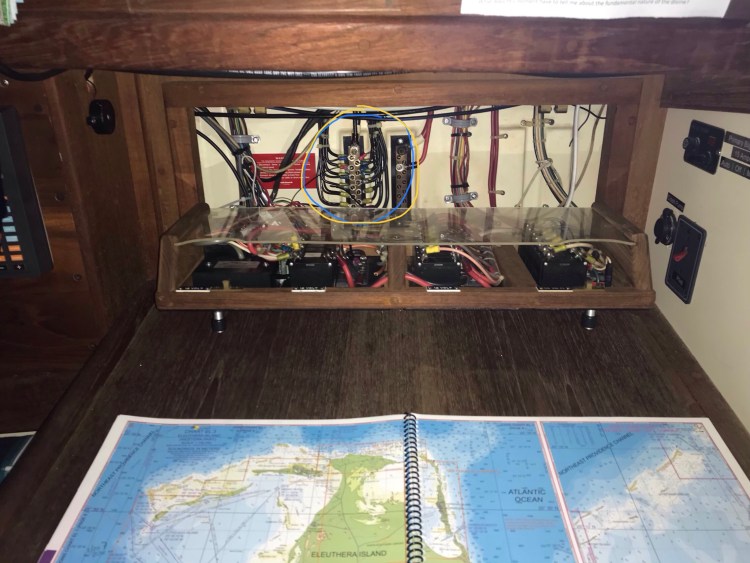
As opposed to a house that runs on 110 and 220-volt alternating current, Hazel James runs on 12-volt direct current. 12 volt current is a lot more sensitive to resistance and faulty wiring connections than 110/220, there’s just not as much electrical differential to power-through corrosion at connections and terminals, frayed wires, etc. Virtually all of this 12 volt power is routed through her electrical panel which sits behind the “nav station”. The nav station (navigation station) is a stand-up desk in her saloon used to layout charts, plot courses and track progress. The electrical panel is akin to a house’s fuse box or circuit-breaker panel. This location of the electrical panel, allows me to monitor HJ’s power consumption and make sure anything not needed is turned off and not drawing power from her battery bank. When the sun is shining and her solar panels are cranking, I can use all the power I want. However, we need to be parsimonious at night and on cloudy days. Especially at night and on cloudy days while on passage and sailing. On passage, you want and need more power to run radios, GPS, radar, running lights and various other safety and navigational gear.

HJ’s nav station with electrical panel immediately behind

I’d been having an intermittent problem with one of Hazel James’ lighting circuits. It’s a series of three lights for the navigation station, head and galley (bathroom and kichen). To put size in perspective, given HJ’s compact layout, the three lights are within 5 feet of each other. Some days the lights would work fine, other days not at all and yet other days flicker on and off. I kept playing around with the power the lights were getting—the red wires on the positive side of the circuit—and all seemed fine. I’d tap connections, poke, prod, etc. in hopes of inducing the problem and zeroing-in on its solution but no luck.

A couple nights ago, at anchor, I was up in the middle of the night checking on the anchor-set and a few other things. I flipped the switch for the nav station light and…nothing. I was at first mad that it wasn’t working and then thought, “Great, if the circuit stays not working in the morning it will help me troubleshoot in the light of day.” Sure enough, when I got to troubleshooting the next morning the lights worked fine. Murphy’s Law at its finest.

Then it hit me, an epiphany for a hybrid sailor/engineer—what if the problem is on the negative (ground) side of the circuit? I’d been focused this whole time on power and the positive side of the circuit. Sure enough, when I opened up HJ’s electrical panel and poked around the ground/negative terminal block (circled below), I found a loose ground wire and was able to force the problem into happening. From there it was a simple matter to tighten the ground wire for that circuit and, while I was at it, tighten all other ground wires on the terminal block. I felt so good about myself, so self-sufficient, so badass.

The lessons learned from the situation stuck with me. Yes, there’s the narrow view of an electrical problem and wires and connections; however there’s the broader application to life and our collective situation with the loss of Colleen. I recently read the book “Option B” by Sheryl Sandberg and Adam Grant. Thanks to Elyse for sending it to me and including a note about how the book had helped her family. Sheryl lost her husband Dave several years ago and Adam is a family friend, psychologist and professor who is helping her through it. While not 100% applicable to our situation with Colleen, it’s a very good read.

In Option B, Sheryl and Adam introduce the concept of PTSG: post-traumatic stress growth. That is, taking a horrible, shitty situation and finding a way to grow from it, and venture forth and do things you would never have done if the situation hadn’t happened. It can turn a negative into a positive.